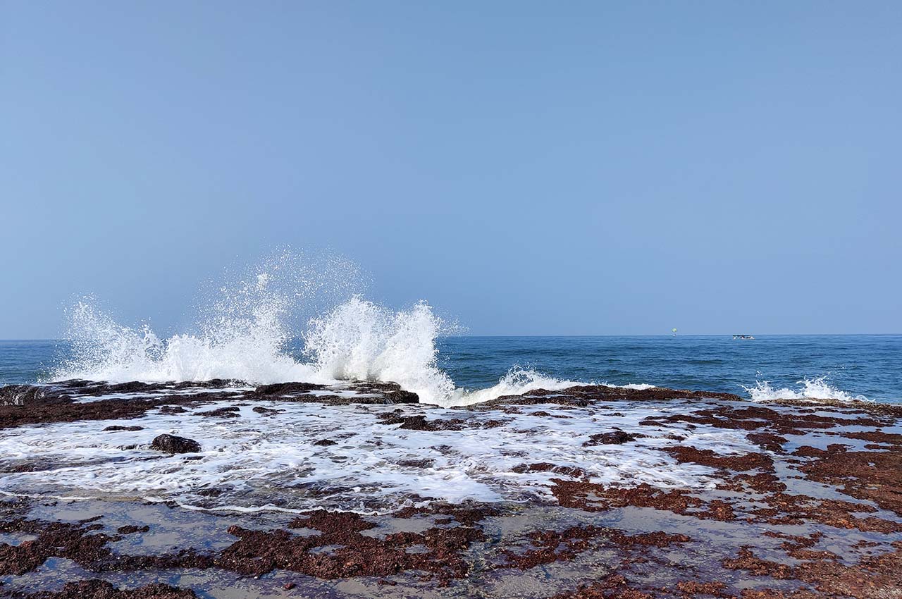
India’s coastline is slowly, but surely, being swallowed up by the sea. The east coast is under greater threat, and at some points along the Bay of Bengal the coastline is receding by as much as 20 metres every year. Though about 225 million people live in coastal areas, the issue does not receive the attention it deserves, since for a majority of Indians in the heartland and interiors the sea is far removed in imagination. The Indian mainland has a 6,632-km coastline, and a little less than half of it is being steadily eroded.
Take the case of Pentha, a coastal village in Odisha’s Kendrapara district. In the half-century after 1960, the shoreline receded by as much as four kilometres. Most of Pentha’s coastline was lost in the 1999 super cyclone. More extensive surveys conducted using satellite imagery show that in a brief 17-year period, starting in 1989, India lost as much as 250 sq. km of land to the advancing sea, most of it along the Bay of Bengal.

According to a report by the Asian Development Bank (ADB), which has financed some coastal protection projects, “given the slope and configuration of India’s coastline, an increase of one metre in sea level could result in a loss of 5,745 sq. km of land which could displace more than seven million people” besides damaging crop land, housing, and other infrastructure.
It is not just Odisha that is suffering from coastal erosion—West Bengal, Andhra Pradesh, and Tamil Nadu besides the Andaman and Nicobar Islands too face the risk of land submergence. Part of the cause of coastal erosion is natural or global phenomena like warming and sea-level rise, but a good part can be attributed to ‘anthropogenic’ or human activity. This could be around the coast or upstream along the rivers that join the oceans, providing the coasts with much of their stabilising silt deposits that serve to soften the clash between the seas and the land.

While the west coast is a narrow strip between the Arabian Sea and the Western Ghats with an average width of 50 km running from Kachchh to Kanyakumari, the east coast between the Eastern Ghats and the Bay of Bengal is relatively wider (80 to 100 km) and contains fertile plains, susceptible to damage and destruction by cyclones that occur during the northeast monsoon.
With the recent signing of an accord between India and France to develop a roadmap for the development of the Blue Economy and ocean management, it is in order to analyse its impact on the Indian coastline, since it will be based on a number of ‘anthropogenic’ activities, including fishing, ports, and shipping. While the agreement is ambitious and reflects the draft policy on the Blue Economy, it is equally important to meet targets set by Sustainable Development Goal 14 (SDG 14), which aims to sustainably use oceans, seas, and marine resources.
Severe erosion of India’s eastern coastline that runs from Kanyakumari to the Sundarbans has been confirmed by the Second World Ocean Assessment report of the United Nations published in 2021. According to the second volume of the report, the east coast of India is the second most eroded coast in the world after the Caspian Sea shoreline. The rate at which the coast is being eroded is an alarming 20 metres per year on an average—a figure that is borne out by the experience at Pentha where, of course, the erosion process ocurred at four times this average rate.
In 2015, the UN set up the ‘Regular Process’ whose first cycle of assessment of the global marine environment issue resulted in the first assessment report. The second cycle stretched from 2017 to 2020, while the third cycle is to cover the period from 2021 to 2025. The real work in the third cycle is getting underway now. The latest annual of the World Ocean Summit Virtual Week organised in Lisbon, Portugal, by The Economist in March this year shows the all-round interest in the fate of the seas.

UN Secretary General Antonio Guterres raised a valid point when he said that while the first World Ocean Assessment report had warned that human activity had been the greatest threat to oceans, many areas of which faced serious degradation, six years later the second report showed that the situation had not improved. “We urgently need to change how we interact with it,” he urged, emphasising that the oceans played a crucial role in the achievement of the SDGs and the livelihoods of billions of people. The coastal environments, after all, form the interface between land and sea. They host key infrastructure and ecosystems, and about 40% of the world’s population. In India, about 225 million people live in coastal areas, according to census figures.
It is not just Odisha that is suffering from coastal erosion—West Bengal, Andhra Pradesh, and Tamil Nadu besides the Andaman and Nicobar Islands too face the risk of land submergence
A comprehensive report on the status of India’s coastline and its protection was released by the Central Water Commission (CWC) in 2016, though successive governments have been aware of coastal erosion since the mid-1960s when the problem was first noticed in Kerala. To deal with this, a Beach Erosion Board (BEB) was formed, whose scope was later extended to cover the entire coast as it was realised that the problem was extensive. In 1995, BEB was renamed the Coastal Protection and Development Advisory Committee (CPDAC).
According to the CPDAC, though coastal erosion results from both natural and man-made causes, the latter is often due to ill-planned activities, which is definitely possible to reverse. Natural causes like storm surges or waves or tides are “relentless and often impossible to resist”. Besides, the effects of some other environmental factors like sea-level rise and climate change have not yet been accounted for.
Experts say that though the combined action of waves and tides maintains the stability of the coastline, severe erosion can be caused if the sediment supply to a beach is reduced due to any reason. A major source of coastal sediment is inland erosion that is transported seawards by rivers and redistributed along the coast, creating dunes, beaches, marshes and reefs. So far as India is concerned, there are about 100 rivers which bring large amounts of sediment to the coasts, chief among them being the Ganga, Brahmaputra, Krishna, Kaveri and Godavari in the east and the Narmada and Tapti in the west. According to a 2001 estimate, every year a massive 1.2 trillion kg of sediment is deposited along India’s coastline by these rivers.
Coastal defence structures like sea walls and breakwaters, dams constructed upstream along rivers, sand mining and building of ports and harbours are some of the major factors that disturb the coastline. Removal of vegetation barriers like mangroves or coral mining also result in serious coastal erosion
So, what are the anthropogenic causes identified for changes in the rate of sediment deposition that hasten coastal erosion? Coastal defence structures like sea walls and breakwaters, dams constructed upstream along rivers, sand mining and building of ports and harbours are some of the major factors that disturb the coastline. Removal of vegetation barriers like mangroves or coral mining also result in serious coastal erosion.
A European Commission team of scientists led by Lorenzo Mentaschi has identified dams as the most prominent erosion factor as they retain sediment that would otherwise feed beaches downstream. Among prominent examples in South Asia are the Indus and Brahmaputra or Ganga deltas, which are shared between India and its neighbours—Pakistan and Bangladesh. The report, published in 2018, points out that the coastline of the Indus delta region retreated by 40 km between 1984 and 2015. Though a major portion of the Indus delta falls in Pakistan, nearly 100 km is on the Indian side. This delta, says the report, is associated with one of the world’s most extensive irrigation networks. Both deltas also happen to be very densely populated areas. In the whole of South Asia nearly 3,600 sq. km of land has been lost to the sea during this period.
Though sea erosion has been recognised as a serious problem in India for over half a century, until the early 1990s various maritime states and Union Territories were taking erosion defence measures in isolation from one another. According to another CWC document setting out guidelines for coastal management, while the protection measures are planned and designed, they adversely affect adjacent coasts. After this realisation the government has taken an increasingly integrated and multidisciplinary approach to coastal management, appraising the entire Indian coast and its problems as a whole, and involving several ministries such as environment, forests and climate change and earth sciences in addition to the ministry of water resources.

According to J. Chandrashekhar Iyer, director, beach erosion in CWC, “Each segment of the coastline has its own characteristics. Hence, it is essential to understand in detail the behaviour of the coast in totality and examine various alternatives before arriving at a solution for the specific site.” Earlier, mostly hard measures like constructing sea walls, embankments, breakwaters (that reduce the energy of the waves before they strike the shore) and groynes were resorted to. But soon it was discovered that most of these hard measures have a major drawback—the erosion gets transferred to adjacent areas. That is why thinking in recent years has veered around to a judicious combination of ‘hard’ and ‘soft’ measures of coastal defence.
Soft measures include artificial nourishment of beaches, restoration of coastal vegetation like mangrove and palm plantations, sand bypassing at tidal inlets that have often been blocked by jetties and other structures, and dune reconstruction. While traditional breakwaters fall in the hard category, in recent years soft breakwaters or reefs made of geo-textile tubes filled with sand slurry (mixture of sand, cement and water) have been used. Such geo-textile tubes have been used for the first time in India at Pentha. The triple-layer tubes have helped to withstand three strong cyclones—Phailin, Hud Hud and Fani—since the completion of the construction of the 455-metre breakwater in 2016. A similar hybrid approach of synthetic textile offshore reefs, beach nourishment, and hard berms has been adopted in ADB-assisted projects at Mirya Bay (Ratnagiri, Maharashtra) and Ullal Bay (Mangalore, Karnataka) on the west coast.