Tall promises have been made in recent months by top leaders about reversing global warming within the next half-century. Any roadmap to reach this goal must have two crucial components: monitoring and action, in that order. Ever since the watershed 1992 Rio Summit when the international community for the first time gave a call to minimise damage to the environment by unbridled development, satellites have been increasingly serving as ‘eyes in the sky’ that check out the damage on which concrete protection steps are based.
The growing dependence on remote sensing in monitoring the surface of Earth in all its aspects is evident from the fact that there are, according to information collected by non-profit CarbonBrief, more than 162 climate satellites, active or semi-operational, circling the planet. As a major player, India itself has over the years sent up over 40 Earth Observation (EO) satellites, according to information on the website of its space agency, the Indian Space Research Organisation (ISRO).
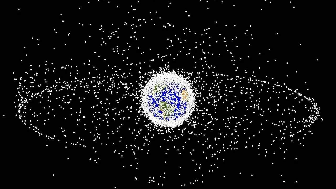
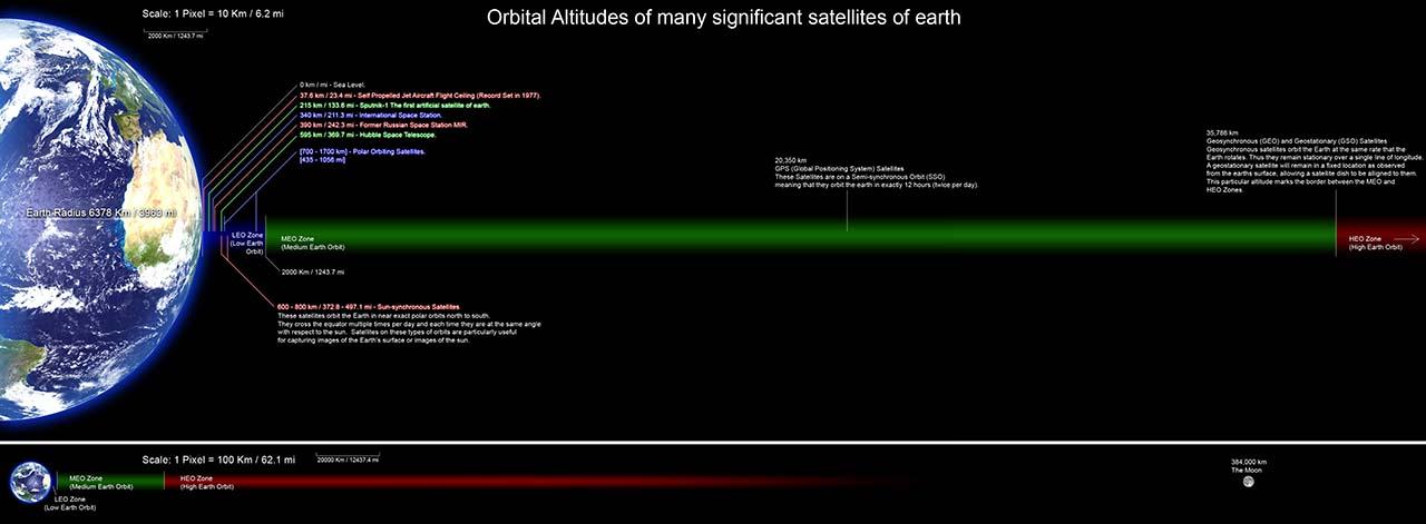
But looming on the horizon is a danger that could prove to be a serious hurdle for remote monitoring: a critical component in the fight against climate change. This danger comes from the increasing clutter of space debris at the altitudes at which most Earth Observation satellites are stationed, collecting high-resolution images. This altitude band, between 250 km and 2,000 km, is known as the Low Earth Orbit (LEO).
According to Space.com, quoting the UN’s Outer Space Objects Index, there were more than 7,500 satellites orbiting Earth in the LEO. In recent years, new satellite launches have exploded exponentially. Up to 2010, anything between 10 to 60 satellites were launched per year but this number shot up to 1,300 in 2020 and 1,400 new launches were carried out in 2021. With increased demand for commercial EO images, satellite data connectivity and navigation, the crowding of LEO and the Middle Earth Orbit (MEO) is going to increase rapidly in coming years.
Earth’s atmosphere extends 10,000 metres and more above sea level, putting most of it beyond the reach of land- and sea-based weather station networks. Though the first satellite to be put in space was the Soviet Union’s Sputnik in 1957, at that time it only served as the starting point of the extension of the Cold War to space. The race in space was pursued for both military and civilian purposes. By the mid-1980s satellites began to be seriously used for the study of Earth itself and space began to be used for peaceful purposes. This effort was started by the US, which sent a set of three satellites under the Earth Radiation Budget Experiment (ERBE) between 1984 and 1986 on the space shuttle Challenger. The objective was to study the exchange of energy between the Sun, Earth and space and its impact on weather and climate. This was followed by the Clouds and the Earth’s Radiation Energy System (CERES) programme which launched the Tropical Rain Measuring Mission (TRMM) satellite in 1997.
These were also the years that marked the break-up of the Soviet Union and the end of the Cold War, leading to the rise of Europe as a group of nations with growing economic clout that came to acquire the name of the European Union (EU). This group developed its own joint space programme under the aegis of the European Space Agency (ESA), which has sent up a series of satellites named Sentinel under its CopernicusEarth Observation programme.
Dr Richard Engelen of the Copernicus programme has explained the importance of the use of remote sensing to check climate change. “The whole idea is that if we are serious about taking action to mitigate climate change, we need to be able to monitor those actions,” he said in a recent interview to the BBC’s SkyAt Night magazine.
Satellites, in general, can be broadly classified into three categories, based on the height of the orbits in which they are parked—Geostationary Orbit (GEO), MEO and LEO. Geostationary satellites orbit Earth at an altitude of more than 35,000 km and stay rooted over a fixed spot on Earth. They can therefore continuously monitor that fixed spot over a long period of time. Most EO satellites, however, occupy the altitude band between 400 km and 1,400 km, according to the data of the World Meteorological Organisation. LEO orbits allow satellites to directly monitor the climate from their position within or just above the atmosphere and can provide near-global coverage as they scan different swathes of ground with each orbit.
According to information collected by non-profit CarbonBrief, more than 162 climate satellites, active or semi-operational, circle the planet
India has a number of climate satellites in orbit. The most important ones are the Cartosat series, the Risat series, the EOS series, the Oceansat series, and the IMS and the IRS-Resources at series. India is a major player in space along with the US, Russia, the ESA and China. India has cooperation with the first three in space and several of its satellites have been put in orbit by European and Russian (earlier Soviet Union) launchers. Currently, it has 14 climate monitoring satellites in orbit, behind only the US and China.

But whether the serious commitments to reduce greenhouse gases, particularly carbon dioxide emission, made at the Glasgow climate summit late last year are achieved will depend to a large extent on accurate monitoring of the atmosphere to find out if the steps taken in this direction are having the intended effect. In this, remote sensing, which involves the collection of data from an area without direct contact with it, plays a big role. It includes the use of satellites, planes and drones. Satellites provide an unrivalled global view of what is happening everywhere, including the southern oceans and the Arctic and Antarctic as well as other sparsely populated regions. Sea surface temperatures, for example, which are a measure of global warming, can only be accurately collected by satellites, particularly those in LEO.
But increasing numbers of satellites being launched, both by governments and private entrepreneurs, over the past decades, has resulted in burgeoning space debris at these crucial LEO altitudes, particularly in the past decade. As of today, there are an estimated 9,300 tonnes of debris floating around in space, 70% of which is in LEO.
The serious commitments to reduce greenhouse gases made at the Glasgow climate summit last year will depend on accurate monitoring
Even small pieces of debris can pose a grave danger to monitoring instruments aboard satellites, as was discovered in the case of a camera mounted on ESA Copernicus Sentinel 1. A malfunction in a solar panel was found to have occurred due to a collision of a 1-mm piece of debris with the panel. The debris is made up of derelict spacecraft, spent rocket stages, hardware released during missions, exploded motors and more, which are hurtling around at frightening speeds of up to 25,000 km per hour. At these speeds, even a one-centimetre piece would behave like an exploding hand grenade if it collides with a spacecraft.
In addition to such debris left over from launch stages and dysfunctional satellites, there is a new danger that is rearing its head—collision between satellites. One of the worst collisions of this kind occurred in 2009 when a Russian military satellite, Kosmos 2251, crashed into a private American communications satellite, Iridium-33, at an altitude of 776 km above Siberia. Both were destroyed in the collision that created 2,300 pieces of debris, many of which re-entered Earth’s atmosphere and burnt up. But the worrying aspect was that some of the debris travelled upwards to about 1,000 km where it will remain in orbit for several decades and pose collision risks to other satellites.
Earlier, large amounts of debris were usually generated by accidental explosions like the one that occurred in 1986, when a second-stage rocket of Arianne 1 exploded spontaneously, breaking up into 492 pieces. The debris overcrowding was anticipated by a NASA astrophysicist, Donald J. Kessler, way back in 1978. He visualised a situation in which growing traffic in space would lead to collisions and the generation of debris. The debris could collide with other satellites, resulting in even more debris. This would set off a chain of cascading collisions, creating so much debris that it would one day become hard to access LEO or even for spacecraft to leave Earth’s orbit. This phenomenon has since acquired the name of the Kessler Syndrome.
Debris could collide with other satellites, resulting in even more debris. This would set off a chain of disastrous cascading collisions
Data collected by ESA shows that there are more than 10 times the number of man-made objects in space today compared to 1970, when there were just 2,000 objects. In 1960 there weren’t any such objects. The number of objects larger than 1 cm is 900,000. The sharpest rise appears to have taken place in the decade following 2010 during which more rocket and payload fragments entered space than in the previous five decades of space exploration put together. Many thousands more are expected to be added since a number of private players have joined the fray for the commercialisation of space. It is estimated that by 2030 there may be 100,000 commercial satellites.
After deliberating for over a decade, the United Nations Office for Outer Space Affairs (UNOOSA) issued space debris mitigation guidelines at the end of 2007 that was endorsed by the UN General Assembly. But it will obviously take time for its impact to be felt. In the guidelines, UNOOSA acknowledged that the future would see greater amounts of debris generated by collisions between satellites—a forecast that came true a little more than a year later. But the drawback of the guidelines is that they are not backed by international law; therefore, their implementation is entirely voluntary. State space agencies could be expected to adhere to these guidelines, but private companies would be reluctant to do so because of cost implications in the absence of legal compulsion.
The set of seven guidelines recommends short-term and long-term action to check the generation of space debris. While short-term measures are already being followed, long-term measures are difficult to implement given that technology for them is still at the experimental stage. The long-term measures include end-of-life procedures that remove decommissioned spacecraft and launch vehicle orbital stages from regions occupied by operational spacecraft. So far only one satellite has been pulled out of space by ESA in 2019. Only when both types of measures begin to succeed can we hope to free the LEO region of debris so that Earth Observation satellites, which are so essential for achieving climate goals, can function without risk.
The seriousness of the situation can be gauged by the fact that mathematical modelling has shown that even if all launches are stopped, the number of objects in space will continue to grow because collisions are happening and producing fragments at a higher rate than those that are decaying. Some astrophysicists believe that the chain cascading of debris has already begun.
Therefore, if the international community is serious about achieving climate goals and being seen doing it, they must take urgent steps to put in place a more robust space debris mitigation regime.