Students from 18 schools across the country presented new ideas on how geospatial technologies can be embedded to address local challenges like protecting the heritage, soil fertility, crop diversity, clean city, water management, women empowerment, waste management, digital India, clean energy, climate change and so on to achieve sustainable development goals (SDGs).
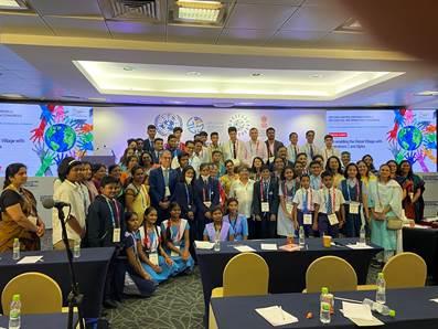
Teams from 18 urban and rural schools across India showcased the use of geospatial information and technology in understanding local issues and its use in planning and implementing at a special event titled ‘Geo-enabling the global village with Generation Z and Alpha’ of the Second United Nations World Geospatial Information Congress today (UNWGIC).
Efforts in mapping chemical fertilizer use in farms, as well as their production against organic fertilizer usage along with their production, were showcased. Students also highlighted initiatives of mapping rural biodiversity loss over time, as well as mapping of local recyclable products to source them effectively and increase their usage.
The young teams focused on SDGs of zero hunger, gender equality, decent work and economic growth, sustainable cities and communities, responsible consumption and production, climate action, and life on land. The event could show the way to localize the implementation of the SDGs through geospatial thinking.
In his address, Stefan Schweinfest, Director UN Statistics Division, said that SDGs is not just a document but it is a proper action plan to engage with each other, work together and bring solutions for a better world. “All the projects are truly incredible and great examples for localising the SDGs. Rather than competition, the purpose of this session is to interact with each other, make friends and discuss how to take the ideas forward in the future so that you can be a UN representative for SDGs,” he added.
Subha Pandey, Scientist, Department of Science and Technology (DST), who chaired the session, elaborated on the DSTs activities and emphasized on geospatial technology use at school and community levels to localize SDGs.
The Second United Nations World Geospatial Information Congress (UNWGIC 2022) is being held at Hyderabad International Convention Centre (HICC), India, from 10 to 14 October 2022 with the theme ‘Geo-Enabling the Global Village: No one should be left behind. It has been convened by the United Nations Committee of Experts on Global Geospatial Information Management (UN-GGIM) and organized by the Department of Economic and Social Affairs of the United Nations and hosted by the Department of Science & Technology (DST) – Ministry of Science and Technology, Government of India.